Revolutionary War Maps
Lesson Plan
Created by Ethan Hamilton

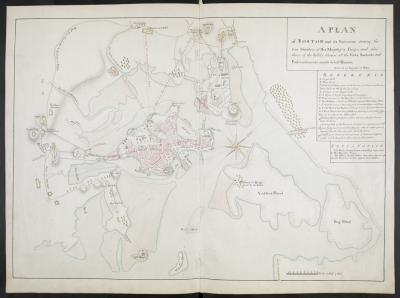
(Plan of Boston)
Core Theme:
Revolutionary War
Grade Level:
8th
Duration of Lesson:
One 45-50 minute period
Content Standards:
Grades 6-8, HIST E: Explain the causes and consequences of the American Revolution, with emphasis on both Colonial and British perspectives.
Lesson Summary:
Students will compare two Primary Source maps for Boston and the surrounding area. One commissioned by the British and the other commissioned by Gen. George Washington. Students will match up these two maps and then do a comparison of them, looking at accuracy and detail. They will then be asked which side has the advantage. We will be then using that information to analyze the advantages of good maps vs. local familiarity.
Materials:
Materials Needed/Used: Pencil, notebook paper, document analysis worksheet
Primary Sources:
A plan of Boston, and its environs, shewing the true situation of His Majesty's army, and also those of the rebels. Drawn by an engineer at Boston, Octr. 1775. The principal part of this plan was survey'd by Richard Williams, Lieutenant at Boston ... Engrav'd by Jno. Lodge.
Map of Boston. 1775, Library of Congress Geography and Map Division Washington, D.C. 20540-4650 USA dcu
Instructional Steps:
1. Introduction: Before we go into battle, what do we need?
a. List items on board: Food Weapons, Soldiers, Information
b. What kind of information are we looking for (do we need?)
i. Enemy’s location, geography, numbers, etc
2. Have the kids take the maps out of their envelopes
a. What are we looking at? Get answers
b. Hand out & complete the document analysis worksheet.
3. After analyzing these two maps. Who do you think has the advantage? (English)
a. Why?
4. Draw a map of your community (Smithville, Marshallville, Wooster, Orrville)
5. Compare similar community maps.
a. What are the differences and similarities between your maps?
b. Why do these differences and similarities exist?
c. Local familiarity gives can give an advantage over artistically accurate maps sometimes.
6. What are some other examples where this could also be true?
a. What ultimately happened in and around Boston?
i. Lexington & Concord
ii. Siege of Boston
iii. Breeds/Bunker hill
iv. Continental Victory
7. Did any of these have to do with the maps used?
a. Why or why not?
Assessment:
This is more of an introductory activity for the beginnings of the Revolutionary War, so the assessment is mostly informal. It is important to make sure that student give feedback to the questions posed and that they complete the
.
