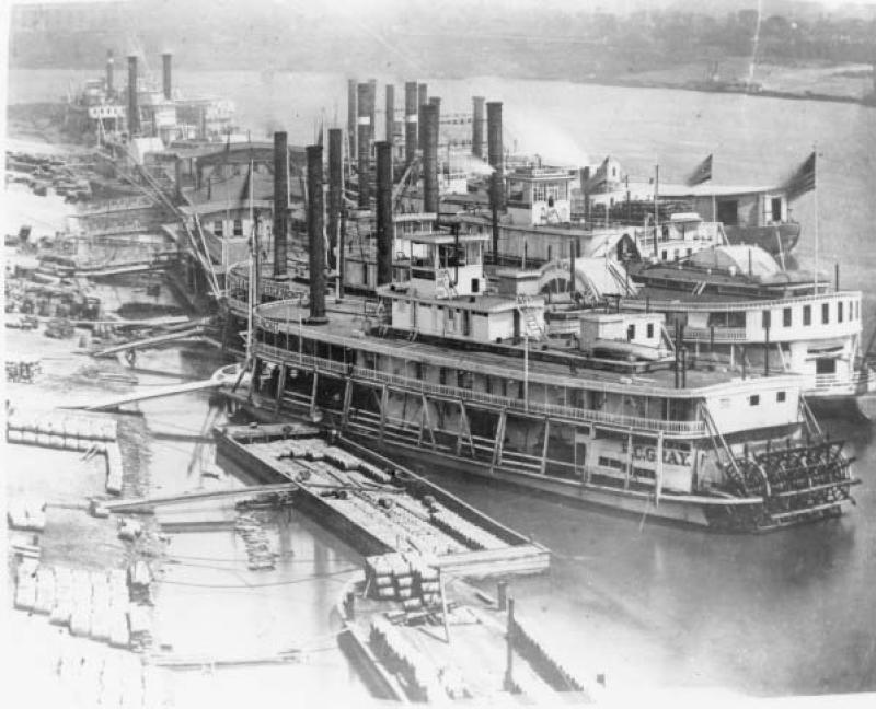
The Progression of Transportation in Ohio and the West
Lesson Plan
Lesson Created by Ethan Hamilton, Michael Moody, Patricia Sage, & Kathie Tisher

Grade:
5
Estimated Duration:
(40 minutes/day: 2 days)
Objectives:
1. To investigate the changing geographic patterns in the United States.
2. To define the impact of immigration and westward expansion on the geographic patterns of the United States
3. To understand cause and effect. Historical events usually have multiple causes and multiple effects, some of which are not recognized until long after the event occurs.
4. To gain a better understanding of the relationship between transportation and western expansion and how these developments affected the local economy.
5. To examine historical documents to gather information and draw conclusions.
6. To gain skill in analyzing documents as historical evidence.
Ohio Academic Standards Connection:
Theme: Regions and People of the Western Hemisphere
Strand: History
Topic: Historical Thinking
Content Statement: 1. Multiple-tier timelines can be used to show relationships among events and places.
Theme: Regions and People of the Western Hemisphere
Strand: History
Topic: Heritage
Topic: Heritage
• Ideas and events from the past have shaped the world as it is today. The actions of individuals and groups have made a difference in the lives of others.
Content Statement: 3. European exploration and colonization had lasting effects which can be used to understand the Western Hemisphere today.
Theme: Regions and People of the Western Hemisphere
Strand: Geography
Topic: Human Systems
Content Statement: 7. Variations among physical environments within the Western Hemisphere influence human activities. Human activities also alter the physical environment.
Materials Needed:
- File
- Pencils
- SMARTBOARD/Internet access/Whiteboard
- Handouts of primary source documents and photos
- Video: Progress of Transportation in Ohio and the West, (https://vimeo.com/27920361)
Modifications used in class for all IEP/Strategic Intervention students are the following:
Differentiated for IEP students:
- Cueing is used to stay on task.
- Directions clarified through repetition and written format.
- Oral responses
- Scribe for written response
- Grouping/ability—document analysis assignment will be based on reading levels.
- Students can work independently, in pairs or heterogeneous groups to complete the journal activity.
Differentiated for accelerated:
Predict what would have happened if the US transportation system had not developed in the order in which it did.
Primary Sources:
Summary Overview:
At the start of the nineteenth century, Ohio was isolated geographically. The Appalachian Mountains on the east, Lake Erie to the north, and the Ohio River to the south, isolated the state from its neighbors. During the nineteenth century, new transportation systems formed, granting Ohioans easier access to all parts of the United States of America. In the first decades of the 1800s, water travel became easier with the invention of steamboats. Beginning in the 1820s, canals provided Ohioans with a cheaper and faster form of travel. In the 1840s and 1850s, railroads emerged, allowing Ohio residents to ship their products to market much more easily and quickly.
Guiding Questions:
- How did transportation affect daily life of the people in Ohio and how does it still affect them today?
- How did these changes affect the way people and commodities traveled?
- Why do you think these changes occurred?
Instructional Procedures/Strategies:
Day 1:
Pre-assessment Overview of Transportation
Pre-assessment
KWL chart (15minutes)
Activity: Photo/Picture Analysis
Divide into groups to use , , or as appropriate on images from Images for Analysis file or Chronology Files.
Discussion:
Why one system of transportation is better than another. Students can refer to the sources they analyzed.
• River to canals
• Canals to steamboats
• Steamboats to railroads
Day 2:
Activity: Creating a timeline with primary sources
1. Distribute Chronlogy Images to students
2. Students will then need to line themselves up in the correct order
3. Once this is done, then can look at their pictures in order of development of the transportation systems from early river travel until the growth of railroads.
Discussion:
How did transportation affect daily life of the people in Ohio and how does it still affect them today?
How did these changes affect the way people and commodities traveled?
Post-Assessment:
Adminster Written of objectives and guiding questions
The Primary Sources used:
Documents are taken from the following:
Canals: Video
Steamboats: Video
Railroads: Video
Ohio River: Video
Art & Photos
(Resources were also obtained from other web site pages which are no longer available.)
Images for Analysis:
Images:
1. Bridge on Miami-Erie Canal. Engraving, 1842. OHS SC 967. Image No. AL02823.
2. Canal Boat Moving Through Lock. Photograph, before 1907. OHS P 223. Image No. AL00883.
3. General Store with Canal Boat. Lithograph, ca. 1830 to 1840s. OHS OVS 5851. Image No. TAH1347.
4. Steamboats, Cincinnati. Photograph, ca. 1872. Public Library of Cincinnati and Hamilton County.
5. Building Railroad.
6. Train in the west with Indians on hilltop.
7. Atchison, Topeka, and Santa Fe RR Broadside. 1876. OHS OVS 1415. Image No. TAH1344.
Other Resources:
Resource materials/books available for students to use as supplemental classroom resources:
Picture books
Andrew Santella. The Erie Canal. Minneapolis: Compass Point Books, 2005.
Martha E. Kendall. The Erie Canal. Washington, DC: National Geographic Society, 2008.
Video access: United Streaming (district license purchase): Discovery Education
Building the Erie Canal segment--(7 minutes 29 seconds)
Construction of the Erie Canal segment—(2 minutes 4Q seconds)
History of Transportation Barges (full video) 18 minutes 27 seconds)
The History of the Steamboat: A Revolution in Transportation segment—(4 minutes and 32 seconds)
The History of Transportation: Railroads (full video) 18 minutes and 27 seconds)
